


Urban Planning
Urban planning shapes the daily urban environment – how we move, spend time, and use spaces – and is therefore a fundamental part of creating a green city.
The world is urbanizing – more than half of the global population currently lives in cities. Growing urbanization and the concentration of people in cities create both opportunities and challenges: more than 70% of the world’s energy is consumed in cities, and cities are responsible for approximately 75% of greenhouse gas emissions. Consequently, urban planning becomes a crucial aspect in creating green, sustainable, and climate-resilient cities.
How a city is planned and developed determines people’s daily lives – how they move (more on Transport), what environment they live in and how they feel in it (more on Nature Protection), where and how they meet, spend time, and build communities (more on Community). Urban solutions shape not only the physical environment but also people’s choices, habits, and lifestyles.
Modern urban planning increasingly focuses on compact city principles, aiming to reduce urban sprawl and more efficiently use already urbanized areas. Instead of expanding into new territories, greater attention is paid to reusing, converting, and revitalizing existing spaces and buildings, creating mixed functions and vibrant urban areas. This is closely linked to the 15-minute city concept, where essential services, work, education, leisure, and green spaces are accessible within a short distance by foot, bicycle, or public transport, reducing distances and reliance on cars.
Urban planning also plays an important role in adapting to climate change – by planning green and blue spaces, creating shade, improving rainwater retention, reducing the urban heat island effect, and increasing the city’s resilience to extreme weather. In this way, urban planning becomes not only a tool for urban development but also for climate change management and improving quality of life, helping to create a city that is good to live in today and that will be resilient to future challenges.
Key Questions
What is a 15-minute city?
The 15-minute city concept is an urban planning concept that aims for most daily needs and services, such as workplaces, educational institutions, healthcare facilities, shopping, and leisure areas, to be accessible within a 15-minute distance by foot, public transport, or bicycle from any part of the city. This aims to reduce traffic congestion, improve residents’ well-being, and enhance their quality of life.
What is the urban heat island effect?
What is green infrastructure?
What is sustainable construction?
What is universal design?
Situation in Tauragė
Tauragė’s urban structure has formed over several distinct historical periods. Before World War I, the city developed as a trade and border center along the Jūra River, but a large part of the city was destroyed during World War I and II. During the Soviet occupation, Tauragė was rebuilt according to the principles of functional modernism, which is why today the city center intertwines historical accents with Soviet-era and later building layers, and the urban structure is characterized by fragmentation.
Today, Tauragė is characterized by low residential density and individual housing. In 2018, 1-2 apartment residential buildings constituted 93.9% of all residential buildings, and their area accounted for 69.2% of the total housing stock. The average population density in built-up areas is 22.33 residents/ha, whereas the recommended minimum density is 30 residents/ha, with a long-term goal of 50 residents/ha. At the same time, in 2024, as many as 62% of issued construction permits were for construction in undeveloped areas, indicating the city’s outward expansion and urban sprawl trend.

Considering this, the solutions outlined in Tauragė City’s General Plan emphasize that to become a climate-neutral city, priority should be given to the modernization, reconstruction, conversion, and densification of existing areas, rather than new development.
An important part of urban planning is green and blue infrastructure. In 2024, an analysis of Tauragė City’s green infrastructure needs, based on data and a resident survey, helped identify areas lacking greenery, shade, and better environmental quality. At the same time, key recreational hubs emerged – the banks of the Jūra and Beržė rivers, city parks, and central squares, which are important for daily recreation and the quality of urban life.
The existing urban structure reveals that the city’s future development depends on decisions regarding how already urbanized areas will be used, how public spaces will be formed, and how green infrastructure will be integrated.
Anticipated changes in Tauragė
Preservation and strengthening of existing green infrastructure
– existing green infrastructure, including urban greenery, riverbanks, and other natural elements, will be protected, maintained, and strengthened. Stream renaturalization and enhancement of recreational potential are planned, restoring natural forms, ecosystems, and hydrological cycles, as well as strengthening existing green spaces by increasing their species and functional diversity and improving maintenance.
Creation and integration of new green infrastructure into the urban fabric
Greening of multi-apartment buildings, educational institutions, and public building environments
Sustainable water management and climate change adaptation solutions
Revitalization of the city center and historical areas
Creation of a walkable city
Planning of public spaces according to universal design principles
Projects

Renovation of Church Street
Church Street is an important part of Tauragė city, where different people, stories, and lifestyles meet daily. The team of BLUMA architects and urban planners, together with Tauragė Municipality and the city’s residents, is embarking on a journey of change for Church Street. Tauragė residents are invited to submit their opinions and ideas regarding the street’s transformation. More information can be found here.

Tauragė City Green Space Maintenance Information Model
An innovative information model for Tauragė city green space maintenance has been developed and implemented. The project aimed to modernize and optimize the management of the city’s public spaces, particularly green areas and green spaces, by utilizing advanced geographic information system (GIS) solutions. The project was implemented in collaboration with UAB “Hnit-Baltic” and funded through GovTech Lab Lithuania.

Picnic Park Established
The “Picnic Park” project is a participatory budget initiative, proposed and selected by the residents of Tauragė District, and implemented by Tauragė District Municipality. In 2022, trees were planted, benches and tables were installed, and outdoor grills were set up in the new park. A children’s playground is also planned for the future. The park is easily accessible not only on foot but also by bicycle – environmentally friendly transport can be secured to the bicycle rack installed in the park.

Mission for a Climate-Neutral Municipality by 2030
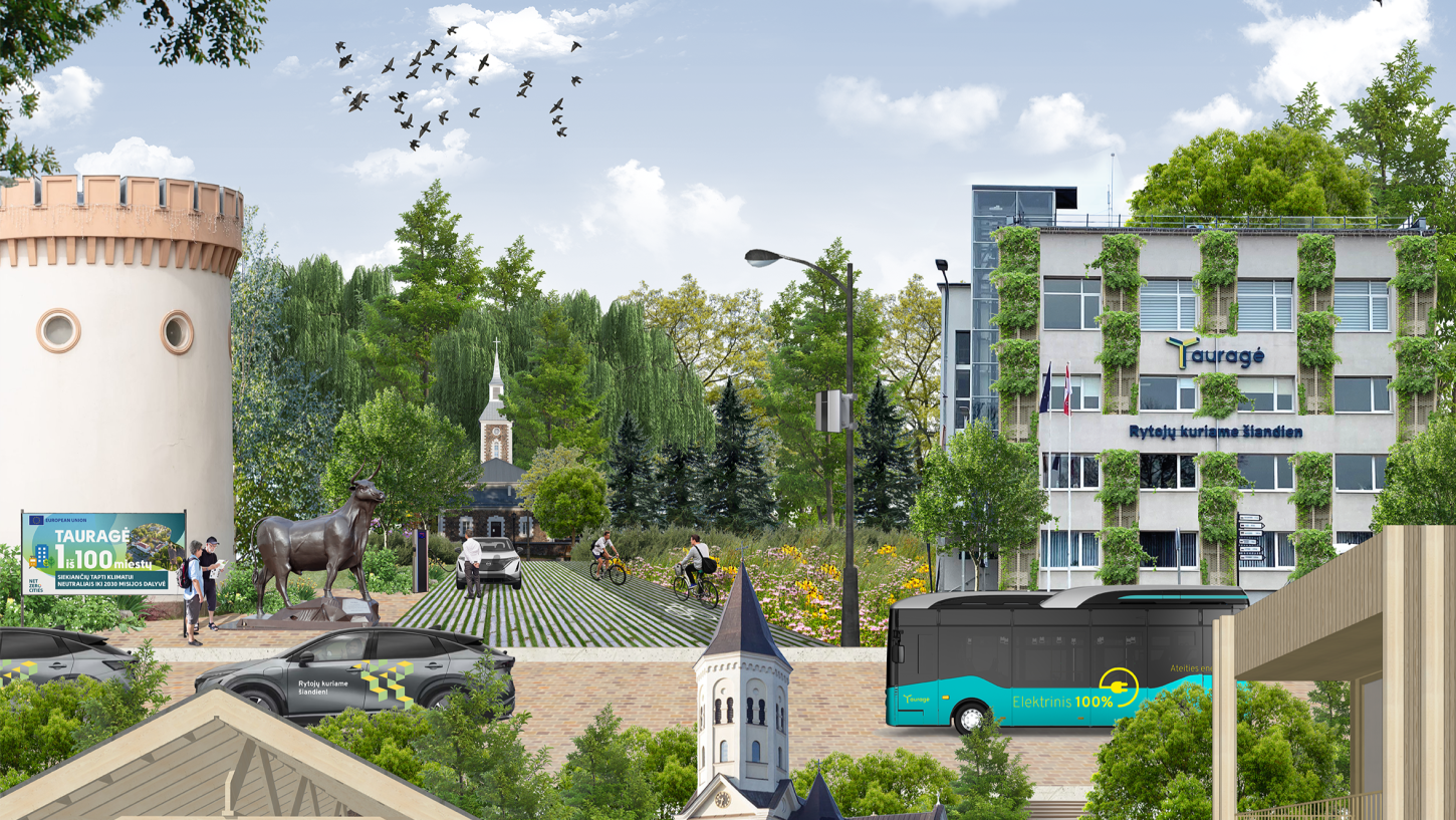
In 2022, Tauragė District Municipality was included in the list of 100 European cities that, under the EU mission “100 Climate-Neutral and Smart Cities,” will aim to implement an experimental innovation program and become climate-neutral settlements by 2030. Learn more – Cities Mission.

Parking Lots Based on Green Infrastructure Principles
A 50-space parking lot has been designed near the multi-apartment residential buildings at Gedimino St. 6 and 8, and Žemaitės St. 3. Following the prepared Green Infrastructure recommendations, a bioretention swale for rainwater collection has been installed in the parking lot, the parking spaces are made of water-permeable concrete pavers, and trees and shrubs have been planted in and next to the lot.

Imagination’s Twists
In 2022, the project “Imagination’s Twists” took place in Tauragė. The project’s goals were to engage the municipality’s residents at various levels of participation, stimulate their imagination, and, through various facilitation methods, help identify common directions for the further development of the former hippodrome area. The project results can be found here.

Redevelopment of Generations (Zumpė) Park
The redevelopment of Generations (Zumpė) Park commenced in 2016. New green spaces were created, pedestrian pathways and lighting were installed, benches and bicycle racks were set up, and children’s playgrounds and other recreational facilities were established. This park is located in the most densely populated part of the city, making its renovation a significant project for promoting healthy, active leisure and community spirit.
Tauragė City Greening Plan
The Tauragė City Greening Plan was prepared in 2025. It envisages the creation of a unified green space network, strengthening of the natural framework, reduction of impervious surfaces, and the development of green roofs and vertical landscaping. The plan emphasizes climate change mitigation measures, adaptation of public spaces to residents’ needs, and the creation of an attractive environment. The document can be found here.

Kaunas University of Technology Architecture Students’ Exhibition: “Tauragė: Visions of a Green City”
In 2023, in collaboration with architecture students from Kaunas University of Technology, future urban visions and the green transformation of Tauragė were explored. The students investigated various urban challenges, including Tauragė’s historical, economic, natural, social, and cultural environment, and developed urban planning strategies. The project results can be viewed here.

Climate Change Adaptation Mission
In 2023, Tauragė District Municipality joined the EU Climate Change Adaptation Mission, which aims to strengthen urban resilience to climate change impacts. The goal is to better understand climate change risks, adapt more effectively to the changing climate, and test and implement solutions needed to increase resilience. In 2024, the first Tauragė District Climate Change Adaptation Plan was developed.


Contact
us


